|
Copyright R. Zamenhof, 2013.
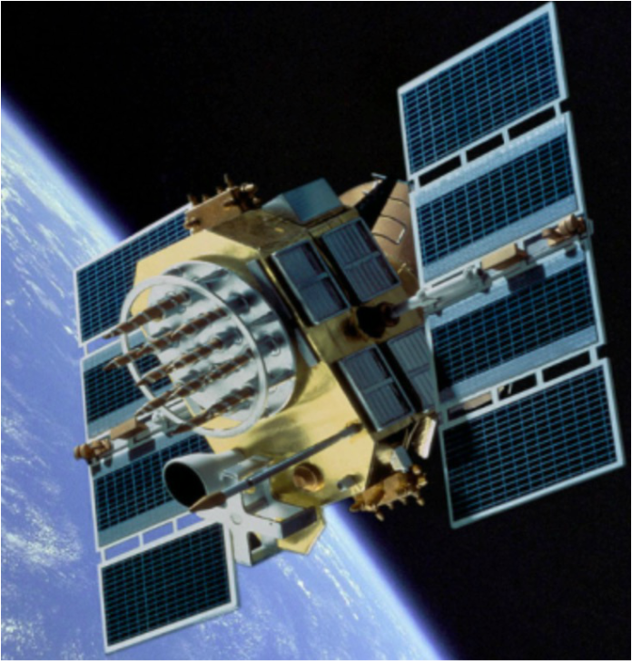
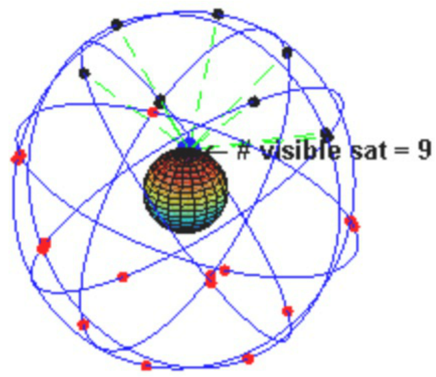
 U.S. GPS satellite, orbiting earth at a distance of 12,550 miles (5% of the distance to the moon). Solar panels provide power. Satellite also contains rocket motors to enable fine repositioning, and nuclear detonation detection "listening" devices so the U.S. military can immediately and precisely locate a nuclear detonation anywhere on earth; useful for test-ban treaty compliance.  Trajectories of the 31 active U.S. GPS satellites circling the earth, twice every 24 hours. At least 6 satellites are visible at any time from any position on the earth's surface. For example, at the head of the arrow 9 satellites are visible. Only 3 visible satellites are theoretically required to determine location, so the additional 6 visible satellites creates a strong redundancy and improved accuracy. Introduction
Global Positioning Systems (GPS) have been a familiar consumer technology for the past decade, but the ingenuity and great complexity of GPS is often belied by its intuitively simple principles. This article describes the principles of how GPS in the U.S. has evolved from the early OMEGA Navigation System in the 1970s, into the highly sophisticated 34-satellite GPS system launched in 1989. Current International GPS functionality is based on a combination of U.S. and Russian federation satellites, that results in a potential localization accuracy of approximately 6 meters (about 20 feet). For military applications such as missile guidance, far greater accuracy is obtainable. Although the most frequent use of GPS is in the consumer market, GPS technology, since 2009, has been in extensive use by the U.S. military. History In the 1970s, the Omega Navigation System developed by the U.S. became the progenitor of today’s GPS technology. Omega was based on receivers comparing the time-of-arrival of signal transmissions from pairs of ground-based transmitting stations and calculating the receiver’s (for example, an aircraft) position by the triangulation principle. Omega became the first worldwide radio navigation system; but, as its technology evolved into three-dimensions using space-based satellites, its access became restricted to military use. The first U.S. GPS satellite was launched in 1989, and the 24th–and last–in 1994. Initially, the civilian sector did have limited access to 3D GPS technology, but the signals available were intentionally degraded by the defense department to restrict the use of the fully accurate GPS system for weapons guidance and other military applications by unfriendly powers. In 1996, recognizing the importance of GPS for civilian air navigation, President Clinton issued a policy directive declaring GPS to be a “dual-use system” and established an Interagency GPS Executive Board to manage it as a national asset. With the removal of the intentional degradation of the GPS signals, the accuracy of civilian-accessible GPS improved from about 300 feet to about 60 feet. In 1998, with aviation civil navigation in mind, Vice President Gore announced plans to upgrade the GPS system with two additional civilian channels for enhanced accuracy and reliability, and in 2000 the U.S. Congress authorized and funded the effort. Current Status of GPS The upgraded U.S. GPS system, consisting of 24 orbiting satellites, is divided into six orbital planes with four satellites in each plane. An orbital plane is like a circular disk, where the edge of the disk defines the path of the satellite. The centers of all these orbital planes coincide with the center of the Earth (as shown in the 2nd picture above at a moment in time when 9 satellites are visible at the point on the earth's surface shown by the head of the arrow). The orbits were designed so that at least six satellites would always be visible within line-of-sight from anywhere on the earth’s surface. Since only three satellites are theoretically needed to establish a receiver’s three-dimensional location, this provided a lot of redundancy to compensate for transmissions blocked by building structures, malfunctioning satellites, etc. Orbiting at an altitude of 12,550 miles (about 5% of the distance from the earth to the moon), each satellite makes two complete orbits every 24 hours, covering the same projected track on the ground every day. From spherical geometry, this means that 4 satellites are visible from each location on the earth’s surface for a few hours a day. This makes positioning a much faster process. As of March 2008, there have been in fact 33 GPS satellites in orbit--31 active and two in retirement that are maintained as spares. In this new arrangement, about ten rather than six satellites are visible from any location on the ground at any moment in time, providing additional redundancy and increased accuracy of the GPS system. The flight-paths of GPS satellites are tracked by dedicated U.S. Air Force monitoring stations in Hawaii, Kwajalein, Ascension Island, Diego Garcia, Colorado Springs, Colorado, and Cape Canaveral, along with shared monitoring stations operated in England, Argentina, Ecuador, Bahrain, Australia and Washington DC. Each satellite is contacted at regular intervals with orbital and software updates using ground antennas. These updates synchronize atomic clocks on board the satellites and correct the satellites’ orbits when necessary. Atomic clocks, the most accurate timing technology in existence, provide the very high timing accuracy needed to synchronize the transmission of GPS radio signals from different satellites and to account for the so-called “Doppler shift,” a discrepancy in timing that occurs when a satellite transmits its signal while moving toward or away from the receiver (the Doppler shift is the familiar change in pitch of ambulance sirens as they move toward and away from a listener). Additionally, changes in atmospheric conditions and air humidity affect the velocity of the GPS signals as they pass through the earth’s atmosphere. Differences in receiver altitude introduce further discrepancies in timing due to the signals passing through less thickness of atmosphere at higher receiver elevations, but this effect is more relevant to aircraft navigation systems than to land-based navigation systems. GPS localization accuracy can also be affected when the radio signals reflect off surrounding buildings, canyon walls, hard ground, etc., due to reflective phase-shifts in the radio frequency signals. Finally, the GPS satellites’ atomic clocks also suffer errors due to Einstein’s general relativity principle. When different satellites viewed by a GPS receiver are moving relative to the GPS receiver at different speeds and/or experiencing different gravitational forces by virtue of different altitudes, their clock speeds will slightly vary. With all the above corrections carefully accounted for, the accuracy of civilian GPS systems today is about 6 meters (about 20 ft.), although for strictly military uses such as missile guidance, the accuracy is substantially improved. Inclusion of WiFi Transmissions in GPS Location More recently, in addition to receiving GPS signals from orbital satellites, some GPS receivers can also detect WiFi signals originating in their close vicinity. The locational origins of these WiFi transmissions are determined by referral to a publicly accessible WiFi database, and by the process of triangulation, the WiFi-determined location of the GPS receiver is found. This is a better system for positioning when the receiver happens to be indoors, in a tunnel, among very tall buildings, etc., since GPS signals experience degradation when passing through masonry or concrete. Russian Federation’s GLONAS GPS System In 1995, the Russian Federation’s satellite navigation system became operational. The system had the acronym GLONAS, which stands for Globalnaya Nvigatsionnaya Sputnikovaya Sistema. Loosely translated into English, this means Global Navigation Satellite System. GLONAS was initially operated by the Russian Federal Space Agency. As with the declassification of the USA’s GPS system, President Vladimir Putin in 2007 ordered all military restrictions to be removed from the GLONOS system so that it could be used by the civilian sector as well as by the military. At the present time, the accuracy of the Russian Federation’s GLONOS system is about 7-8 meters (20-25 feet), similar to the current fully unrestricted civilian accuracy of the US GPS system. Sweden’s SWEPOS GPS System In 2011, Sweden’s SWEPOS network of satellite reference stations, which provide data for real-time positioning, became the first known foreign company to use the Russian Federation’s GLONAS system. In Sweden, the accuracy of GLONOS as integrated to the SWEPOS system is about 1 meter (about 3 feet). An obvious question is how accurately do GLONAS and the U.S. GPS agree with each other. Interestingly enough they don’t! This is because as an absolute origin of its coordinate system, GLONOS uses the North Pole’s global position as measured in 1990 by satellite interferometry, while the U.S. uses the North Pole’s global position as measured in 1984. These two measurements differ by approximately 40 cm (1-1.5 feet). It is interesting to note that as part of its “Maps” application, Apple iPhones and iPads use both the U.S. GPS and the GLONAS satellites for location. Military Uses of GPS The list shown below shows the many applications of GPS by the U.S. military. Navigation: Soldiers use GPS to find objectives, even in the dark or in unfamiliar territory, and to coordinate troop and supply movement. Commander ranks use the Commanders Digital Assistant, while lower ranks use the Soldier Digital Assistant. Target tracking: Various weapons used by the U.S. military use GPS to track possible ground and air targets before flagging them as hostile. These weapon systems pass target coordinates to precision-guided munitions to allow them to engage targets accurately. Military aircraft, particularly in air-to-ground roles, also use GPS to locate targets. Missile and projectile guidance: GPS allows accurate targeting of various military weapons including ICBMs, cruise missiles, precision-guided munitions and artillery projectiles. Embedded GPS receivers, able to withstand accelerations of up to 12,000g have been developed for use in 155-millimeter howitzers. Reconnaissance: Patrol movement can be managed more closely using GPS. Nuclear detonation location: U.S. deployed GPS satellites each carry a set of nuclear detonation detectors, consisting of an optical sensor, an x-ray sensor, a dosimeter, and an electromagnetic pulse sensor, that form a major portion of the United States Nuclear Detonation Detection System. As mentioned earlier, the implementation of GPS technology by the U.S. military, although utilizing the same satellites as those used for civilian GPS, process the satellites' signals differently, resulting in about a factor of 10-50 times greater precision. Summary Global Positioning Systems have been a familiar consumer technology for the past decade or more. The U.S. GPS system evolved from the early OMEGA Navigation System of the 1970s into the highly sophisticated 34-satellite GPS system launched in 1989. Following the declassification of the U.S. and Russian Federation’s GPS systems by President Clinton and President Putin, and the increased technological collaboration between these two countries, the current International civilian GPS functionality results in potential localization accuracy of approximately 6 meters (about 20 feet). The civilian Swedish SWEPOS system of ground-based GPS receivers, integrated with the Russian Federation’s GLONAS system, produces an impressive localization accuracy of about 40 cm (or about 1-1.5 feet). Military uses of GPS have existed since 2009, and include smart-bomb, howitzer shell, and guided missile guidance, target tracking, and navigation by soldiers in unfamiliar territory or at night. The military GPS receivers process the GPS satellite signals differently than those used by civilians and are able to improve the accuracy of GPS navigation by factors of 10-50 times. |
About the Author Archives |
Live Chat Support
×
Connecting

You:
::content::
::agent_name::
::content::
::content::
::content::

 RSS Feed